Seeing Orchards Differently: The LiDAR Advantage
Why Drainage, Terrain, and Frost Protection Matter More Than You Think
-
Pinpoint Water Flow and Drainage Issues
Even subtle elevation changes can affect how water moves through your orchard. LiDAR identifies low spots, pooling areas, and runoff paths—helping you prevent waterlogging, root stress, and disease pressure. -
Understand Cold Air Movement for Frost Protection
Cold air behaves like water—it flows downhill and settles in low-lying areas. LiDAR helps you visualize these frost-prone zones so you can position fans, sprinklers, and sensors more effectively, protecting your crop when it matters most. -
Accurately Calculate Fill Requirements
When low spots are identified, LiDAR data allows you to precisely calculate the volume of fill needed to level the terrain. This helps you budget accurately, avoid over- or under-filling, and ensure long-term stability. -
Improve Access and Safety
Understand slope gradients and terrain variability to plan safer access routes for machinery, staff, and contractors—especially during wet conditions.

What Is a DEM and DSM—and Why Does It Matter?
LiDAR data is used to generate two powerful models:
-
Digital Elevation Model (DEM)
A DEM represents the bare earth surface, with all vegetation and structures removed. It’s ideal for analyzing terrain, drainage, and frost risk—giving you a true picture of how water and cold air will move across your orchard. -
Digital Surface Model (DSM)
A DSM includes everything on the surface—trees, vines, trellises, buildings. It’s useful for understanding canopy height, infrastructure layout, and how elevation changes interact with orchard structures.
Together, these models give you a complete understanding of your orchard, both above and below the canopy.
.png?width=300&height=593&name=Phone%20Mockup%20(1).png)
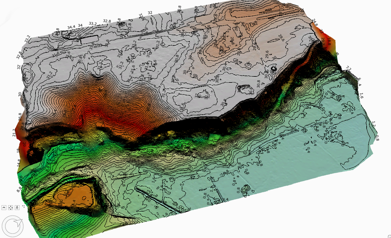
What Is a Contour Map—and Why Is Accuracy Important?
A contour map is a visual representation of elevation across your orchard, using lines to connect points of equal height. These lines help you see the shape of the land—its slopes, ridges, valleys, and flat areas.
With LiDAR, GPSIT can produce contour maps with vertical accuracy typically within ±2 cm, allowing you to:
- Visualize terrain in fine detail
- Identify micro-topography that affects drainage and frost
- Plan earthworks and fill with confidence
- Make informed decisions based on real, measurable elevation data
Accurate contour maps are essential for understanding how your land behaves—and for making smart, data-driven improvements.