Understand the exact size of each Row and Bay
Benefits include:
Targeted orchard management
Efficient input use
Accurate yield tracking
Smarter task management
Simplified compliance and traceability
Precise sizing for Tatau
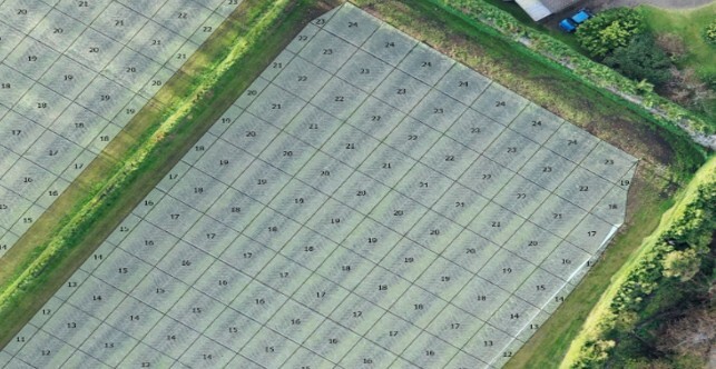
Precision Orchard Management using GPS Enabled Row and Bay data
Integrate your phone’s GPS with row and bay data to pinpoint exact locations in your orchard. Perfect for monitoring vine health, applying inputs, and managing labour efficiently. Greater precision leads to smarter decisions — ultimately boosting yield and improving fruit quality.

Powerful Row and Bay Insights
Accurate data at a surprisingly low cost.
Using drone imagery and surveyed block data, we map row and bay lines for each block. From these features, we can generate accurate row and bay data. Mapping rows and bays is easiest when vine canopy is minimal, allowing clearer visibility of orchard structure.
At GPSit we hold an extensive archive of drone imagery and block data – if your orchard has been mapped or audited within the last 7 years, we likely have sufficient resources to generate row and bay data. Using existing imagery and block information means no site visit, which allows us to keep costs down while still delivering valuable insights for orchard planning and management.
